Dissident political leaders from the Indian state of Manipur on Tuesday said they were unilaterally declaring independence from India and forming a government-in-exile in Britain.
The former princely state became part of India in 1949, two years after the country won independence from Britain, but has since seen decades-long violent separatist campaigns.
Narengbam Samarjit, external affairs minister in the self-declared Manipur State Council, said the exiled government would push for recognition at the United Nations.
“We will run the de jure exiled government here … from today onwards,” he told reporters in London after a declaration of independence first announced in Manipur in 2012 was read aloud.
“We will seek recognition from different nations … to become a [UN] member. We hope many of the countries will recognise our independence.”
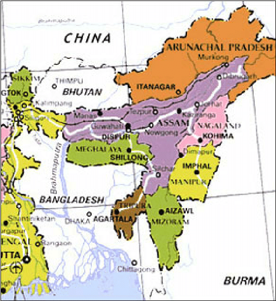
Manipur, one of India’s smallest states with a population of about just 2.8 million people, is one of the so-called “Seven Sisters” – a group of restive northeastern states.
The region, encircled by five other countries and connected to the rest of India by a sliver of land arching over Bangladesh, has been wracked by armed conflict and instability.
Violence part of life
It has spawned more than 100 fighter groups over the decades whose demands range from autonomy to secession.
Violence has been part of daily life for decades in Manipur, which borders Myanmar, with a strong presence of the Indian military.
The state has a strong ethnic mix, and its Meitei, Naga, Kuki and Pangal communities are all deeply committed to preserving their own cultural autonomy.
Its people have also always tended to look eastwards in their search for cultural links.
Samarjit said he hoped the world would support its independence cause.
“We are not free there and our history is going to be destroyed, our culture is going to be extinct,” he warned.
“So the UN should listen … we raise our voice to the whole world that the people living in Manipur are human beings.”
The High Commission of India did not respond to a request for comment.
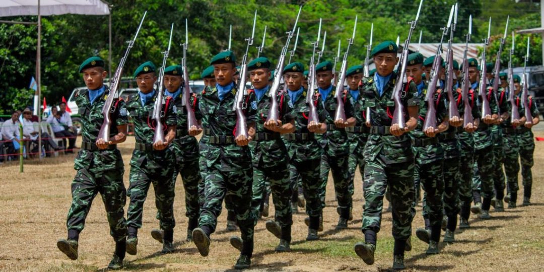
Days before another round of Naga peace talks on October 31, a top leader of NSCN-IM, along with 16 other members, quit the rebel group accusing it of being “insensitive” to the people’s plea for an honourable solution to the vexed issue and joined the rival Naga National Political Groups (NNPGs).
In a statement issued Friday night, Hukavi Yeputhomi said the working committee of the NNPGs has been “practical and realistic” in its negotiation with the Centre.
“Without compromising on our history and identity, I, Hukavi Yeputhomi, former kilo kilonser (home minister) of NSCN-IM and currently a member in the ongoing negotiating team of NSCN-IM, along with 16 co-workers, on our own volition and with clear conscience, has joined the WC NNPG,” he said.
A team of the Nationalist Social Council of Nagaland, Isak-Muivah (NSCN-IM) held talks with the Centre’s interlocutor R N Ravi in last week of October but the discussions remained inconclusive. The next round of talks is expected on October 31.
Sources said the demand for a separate flag and constitution for the Nagas has become the main contention between the two sides with the NSCN-IM, which had signed a framework agreement with the Centre in August 2015, strongly pressing for it.
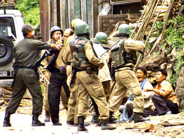
As both sides prepared for a potential renewal of hostilities with the former moving armed cadre and weapons away from designated camps and the latter realigning the counter-insurgency grid comprising the Indian Army and Assam Rifles.
The moves came amidst speculation that the Union government will announce a deal, with or without NSCN (I-M), especially with the Naga National Political Group, a combine of seven Naga organisations that are rivals of the NSCN (I-M), indicating their willingness to do business with the state.</p>
Both Ravi and various rebel groups in the state have referred to an October 31 deadline for announcing the deal. To be sure, the NSCN (I-M) and Ravi are likely to meet again on Tuesday, a functionary of the rebel group said on condition of anonymity. The talks are going on in Delhi.
In Nagaland, which remains on the edge in anticipation of the outcome of talks, two top bureaucrats in the state government said there is no official word from the Centre on the ongoing talks in Delhi or if a pact is likely in the coming days.“There is no official communication at all so far if a peace deal is going to be signed soon or what the discussions have been in New Delhi,” said one of the two officials on condition of anonymity.
But top officials in the security establishment said on condition of anonymity that both the state and the rebel group seem to be preparing for the worst-case.The NSCN(I-M) has around 2,500 armed cadres most of who are armed with sophisticated weapons. The cadres were settled in the six camps spread across Nagaland and Manipur. Camp Hebron in Nagaland was the biggest camp and the headquarters of the NSCN (I-M). “About 90% of their fighting cadre has disappeared in anticipation of the talks failing the Government signing a peace deal without the NSCN (I-M),” one of the security officials who is posted in the state added.
Indian Army troops in Nagaland have been re-deployed to position them better in case ceasefire agreement is abrogated by the NSCN (I-M). The Indian Army has also reached out to the Tatmadaw, the armed forces of Myanmar, to prevent NSCN (I-M) from using vast jungle tracts in Myanmar bordering India as a base, the official quoted above said. In June, the militaries of India and Myanmar carried out three-week-long operation along the border to destroy terrorist camps. On October 20, the state administration asked the Nagaland Police and para-military forces to stock rations and supplies for at least two months in preparation of an outbreak of violence. Earlier this month, as the talks started to stall, the Indian Army Chief General Bipin Rawat was briefed about a possible breach of the ceasefire agreement between the insurgent group and the government.
The NSCN (I-M) and the Union government have been in talks since the mid-1990s. In 2017, the Modi government and the NSCN (I-M) said they signed the “framework for peace” agreement. However, New Delhi has refused to accept the demand for a separate flag, integration of the Naga inhabited areas (including those in other North East states) into one administrative group and a separate constitution — key demands of the NSCN (I-M).
The security officials cited above said the government has intelligence that armed NSCN (I-M) cadre plan to use the Samdrup Jhongkhar jungles along the India- Bhutan border. Separately, around another 250 armed cadre of the NSCN (I-M) are headed for Zaw Khawthar in Mizoram to cross over into the Ri-Khawthar area of Myanmar, they add. Other reports reaching New Delhi suggest that another group led by a self-styled major general of NSCN(I-M) Absolom Tankul has moved into Myanmar after the last round of talks with Ravi failed, they said.
A day after the Government of India and the National Socialist Council of Nagaland – Isak-Muivah (NSCN-IM) failed to put an end to 22-year long parleys by culminating into peace agreement, the State government directed all unit commanders of the state’s police to stock ration and fuel for as long as two months in advance, reports The Hindu.
Given the timing of the instructions issued by the State government, the directive has triggered panic buying among the common people fearing a clampdown of services and shutdown in the region, akin to the one that was imposed in Jammu and Kashmir post abrogation of Article 370 of the Indian Constitution on 5 August.
The panic among the people is triggered by the fear of the peace talks and negotiations falling out as the 31 October deadline for signing of agreement set by the Government of India looks certain to be breached because of belligerence displayed by NSCN-IM over demand of separate flag and constitution which the Government of India has refused to accept.
It should also be noted that in a separate directive issued on 21 October, the State Government has warned of disciplinary action against State government employees upon criticising the policies and actions of the government over social media, press or public meetings.
When Khim Lal Gautam reached the top of Mount Everest at 3 a.m. on May 22, it was dark, windy and lethally cold.
Gautam carried some unusual baggage — a ground-penetrating radar and a top-of-the-line satellite navigation device. Unlike most climbers, he and his team remained at the summit for nearly two hours so they could take the measurements they needed. Gautam suffered a serious case of frostbite, and his colleague nearly died of a lack of oxygen while descending.
But they completed their mission: to obtain crucial pieces of data that will help determine Mount Everest’s true height.
The most commonly accepted figure for Mount Everest’s height is 29,029 feet, a measurement that dates to the 1950s. Some scientists believe that the world’s tallest mountain may have shrunk slightly after a powerful earthquake struck Nepal in 2015.AD
Now, for the first time, Nepal has sent its own teams outfitted with the latest surveying technology to come up with a new measurement of the peak. The two-year, $1.3 million effort is driven both by patriotism and scientific inquiry, experts say.
The southern flank of Mount Everest “belongs to Nepal, but for 170 years foreigners have been measuring its height,” said Roger Bilham, a geologist at the University of Colorado. The current project could be “the most accurate measurement ever made.”
Sometime early next year, the new height will emerge from a modest cluster of offices on the ground floor of a government building in Kathmandu, home to the country’s Survey Department. Susheel Dangol, the chief survey officer, recently installed a keypad-entry system for his department just to safeguard the Everest data.AD
“Everyone is curious about the project,” he said with a grin. During an interview, his cellphone rang with a call from a senior official in the country’s Land Ministry inquiring about the progress of the work. Dangol has developed a stock response to those who ask about the final figure: At the moment, I’m unable to say.
Dangol, 38, oversees a team of 80 people who have hiked, driven and helicoptered across Nepal to gather the data required for an updated measurement. Among their challenges: transporting a $200,000 Canadian-made gravimeter — which measures the force of gravity at a given location — along juddering Himalayan roads to nearly 300 different spots.
The question of Everest’s height is intimately linked to its modern history. It is known in Nepal as Sagarmatha and in Tibet as Chomolungma. The search for the mountain’s English name began after it was declared the world’s tallest peak by surveyors in India in 1856. (Its namesake is George Everest, the prior chief surveyor of India, but even he wasn’t crazy about having the mountain named after him.)AD
Dangol’s team is tackling its task with two methods. The first is to measure Everest the old-fashioned way using trigonometry. Such calculations produced the first-ever tally of Everest’s height, as well as the measurement taken in the 1950s by an Indian team that serves asthe current standard.
But that technique will serve as “a check, a redundancy,” said Christopher Pearson, a research fellow at the University of Otago in New Zealand who consulted with Nepal on the project. The pathbreaking part of the effort will come through the second method, which relies on a combination of readings from a satellite navigation system and a complex model of sea level.
Enter Gautam, a 15-year veteran of the survey department. The 35-year-old had already summitted Everest once before in 2011. This time, however, his four-person team was carrying 90 pounds of equipment in addition to their regular climbing gear. They planned their ascent to arrive at the summit in the middle of the night so their work would not be disturbed by other climbers.
Nepali surveyor Khim Lal Gautam (right) at the summit of Mount Everest in the early hours of May 22. On his left is a satellite navigation device to measure the mountain’s peak. (Khim Lal Gautam)
While most climbers limit their time at the roof of the world to descend quickly from the “death zone,” Gautam and his team “did not have that privilege,” he recalled. They stayed at the summit for an hour and 45 minutes, taking readings with a Global Navigation Satellite System device and a ground-penetrating radar that can gauge the difference between the actual rock summit and the snow that covers it.AD
Wearing bulky mittens against the extreme cold, Gautam and his team couldn’t operate the small knobs on their equipment. So they took off the mittens and worked in fleece gloves instead. For weeks afterward, Gautam had no sensation in his fingers. The frigid temperatures also damaged his feet: He lost the tip of his left big toe to frostbite and now wears only sandals, rather than shoes.
On the descent, all their food and water was gone, and Gautam’s colleague ran out of oxygen, a life-threatening situation. Their climbing guide managed to borrow a bottle from another Sherpa who was heading up the mountain, Gautam said, saving his colleague’s life.
Although the data they carried with them on the way down weighed nothing, “its preciousness made it so heavy,” said Gautam.
Yet the satellite readings from the Everest expedition are not sufficient. They give the mountain’s “ellipsoidal” height — the height of the summit above a smoothed geometric model of the Earth. The readings do not reveal an object’s precise height above sea level. AD
Judging exactly where sea level would begin beneath Everest’s massive tons of rock turns out to be a key question. Generating the model of sea level required lugging a gravimeter, which is carried in a large suitcase-like box, to 297 spots in Nepal. “We have to be cautious and drive slowly,” Dangol said. At each measuring point, the machine must be calibrated before taking readings for two sessions of three minutes each.
The data collection will be completed next month, Dangol said. Then the processing will begin: six people, sitting in a room equipped with high-speed computers and specialized software, for three to four months, checking and rechecking the figures. It will be a “closed camp,” Dangol said. Not even he will know the results at first.
Nepal’s effort has been “incredible,” said Pearson, the surveying expert in New Zealand. “Staggeringly, it has all worked, and they have all the information they need to get an accurate height.”AD
Dangol is already looking forward to next year, when Nepal plans to unveil Everest’s new height — both the rock height and the snow height, down to the centimeter. That will be “kind of like a thesis defense,” he said.
Even the loss of part of his toe did not dull Gautam’s pride in his work. “We are so happy because we finished our difficult task,” he said. “I was ready to take [a] risk for the nation.”
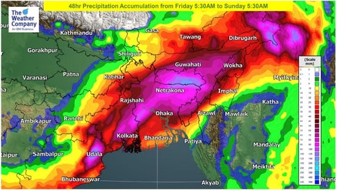
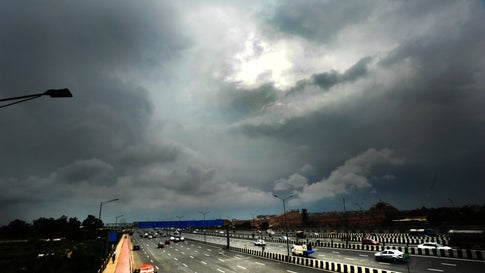
A low-pressure area, currently located over Odisha, is set to bring an intense bout of heavy to very heavy rains over the eastern and northeastern states of India on Friday.
According to The Weather Channel’s forecasters, Assam, Meghalaya and Sikkim will experience heavy to very heavy rainfall on Friday. Moreover, heavy rains are also forecast in Bihar, Jharkhand, West Bengal, Arunachal Pradesh, Nagaland, Manipur, Mizoram and Tripura.
A 24-hour precipitation accumulation (i.e. total rainfall volume) of over 100mm is also possible over eastern and northeastern India on Friday, and over northeast India on Saturday.
Rainfall accumulation forecast during the next 48 hours, from Friday morning to Sunday morning(TWC Met Team)
The India Meteorological Department (IMD) also forecasts that isolated places over Assam and Meghalaya will experience thunderstorms accompanied by lightning and gusty winds (with speed up to 30-40 kmph) over the next 48 hours.
The regional met centre also forecasts the possibility of thunderstorms with lightning across northeastern states on Friday and Saturday. Gale winds of up to 40 kmph are forecast in isolated places over Assam and Meghalaya. The IMD has issued an orange level alert for these two states, while other states in the northeast have been put under a yellow watch. IMD’s orange alert signifies ‘be prepared’ for extreme weather, while yellow watch recommends to ‘be updated’.
The circulation and the related low is expected to move northeastward on Friday, and reach northeastern India on Saturday morning. The intensity of rainfall is likely to drop after Sunday, as the low-pressure loses steam.
Since the start of October, five Northeastern states (Arunachal Pradesh, Assam, Meghalaya, Mizoram and Sikkim) have experienced ‘deficit’ rainfall as compared to the normal average, while Manipur has experienced a ‘large deficit’. However, with heavy rain headed their way, these statistics could change drastically over the weekend.
For weather & air quality updates on the go, download The Weather Channel App (on Android and iOS store). It’s free!
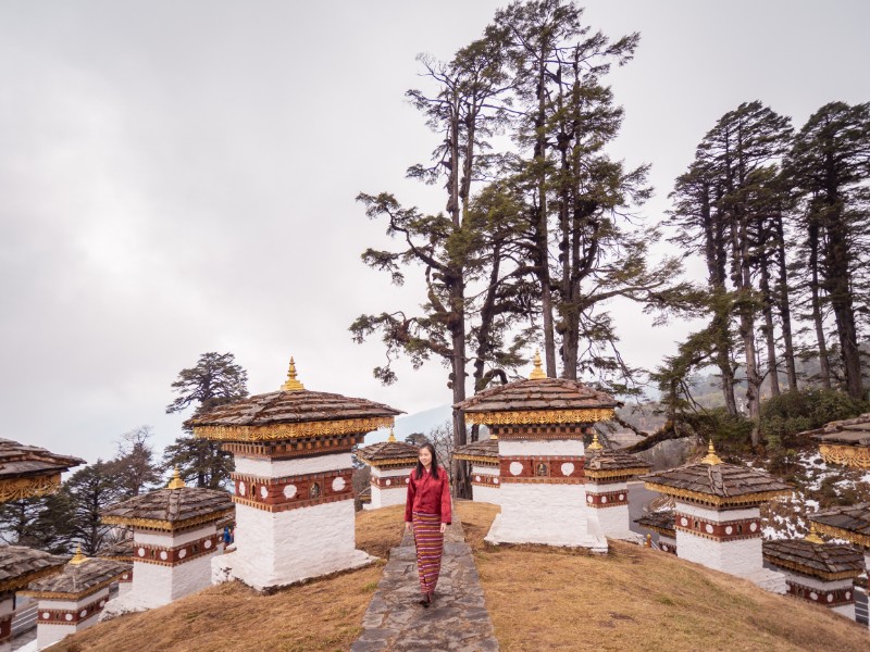
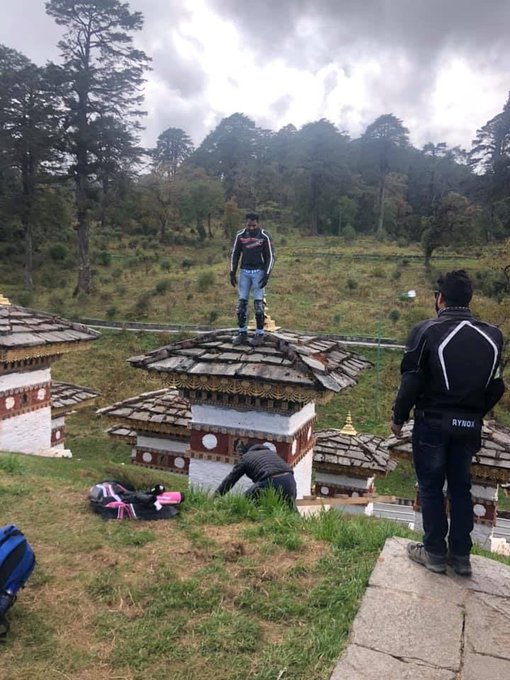
A biker from India was seen standing on the dome of a sacred structure in Bhutan, which has sparked outrage on social media in the Himalayan nation and India, where people criticised him for his behaviour that could embarrass the country.
In a video tweeted by The Bhutanese newspaper, the tourist in a black jacket and jeans with protective biking gear is seen climbing a ladder to the top of the memorial structure at Dochula, 20 km from Bhutan’s capital Thimphu.
There are 108 stupas at Dochula, built in the memory of Bhutanese soldiers who died in a military strike – Operation All Clear – in 2003 to flush out insurgents from India’s north-east region. The insurgents had set up camps in Bhutan along the border with India.
In another photo, a Bhutanese carpenter was seen sitting on the ladder on the dome of the chorten or a religious monument. The local police are looking for him.
The newspaper reported the tourist in the biker outfit has been identified as Abhijit Ratan Hajare, a resident of Maharashtra. “In the second picture the man sitting on the ladder is a Bhutanese citizen and carpenter, Jambay, who was doing repair works on the Chortens,” The Bhutanese tweeted.
There is rising concern in Bhutan against the huge influx of tourists that may damage its fragile ecosystem
“Abhijit was part of a 15-bike convoy headed by a Bhutanese team leader. Incident happened when bikers were resting at Dochula and the team leader was trying to arrange parking for the bikes. The Bhutanese team leader was unaware of the incident,” the newspaper said.
“Abhijit, whose passport has been taken by the RBP (Royal Bhutan Police) has been called in for questioning today. RBP is launching its investigation today. The Indian tourist came across Jambay and he allowed them to climb the ladder. The RBP are in the process of tracking Jambay down,” it reported.
The Indian tourist apologised in writing to the police, after which he was released, the newspaper reported.
Indians don’t need a visa to travel to Bhutan. However, they should have either a passport with minimum six-month validity or a voter identity card.
For some time now, environmentalists and activists in Bhutan have been raising concerns over a huge influx of tourists that may add pressure on the landlocked Himalayan nation’s fragile ecosystem.
Tenzing Lamsang, editor of The Bhutanese that reported the stupa incident first, said unsustainable growth of regional tourists is affecting the country. “The issue is not about discrimination,” he said.
Over 50,000 regional tourists came to Bhutan in 2012, as against 54,685 “international tariff-paying” tourists, Mr Lamsang said. In comparison, over two lakh regional tourists – a huge rise in number – came to Bhutan in 2018 and only 71,807 international tourists came, he added. (NDTV)
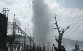
Four men were killed when the pipe that brings water from Kopili dam in the Indian state of Assam to its 275 MW hydropower station burst in the early hours of October 7. Three of them – J Sing Timung, Robert Baite and Prem Pal Balmiki – were employees of North Eastern Electric Power Corporation Limited (NEEPCO), a government-owned firm that operates the project. The fourth victim – still unidentified – worked for a contractor to the project. Hemanta Deka, NEEPCO executive director (Operations and Management), blamed rathole coal mining in Meghalaya for the accident.
Located on the southern bank of the Brahmaputra river that flows through the Assam valley, the Kopili dam is on the river with the same name. The Kopili river flows down to the Brahmaputra from the Meghalaya plateau in the south – and is now infamous for carrying coal slurry and acids used in rathole mining in Meghalaya. This practice, of creating narrow holes of about a metre in diameter in which only one person can enter, has been banned by the National Green Tribunal, India’s top green court, but continues illegally.
Deka says the acids from the slurry had corroded the pipe that was designed to bring water at the rate of 12,000 litres per second. The burst pipe caused a fountain that rose several hundred feet and continued to do so for hours, according to eyewitnesses. The four victims were washed away and their bodies could not be recovered for days. NEEPCO sought help from the National Disaster Response Force (NDRF) and the paramilitary Assam Rifles. It opened all gates of the dam to reduce the water flow to the powerhouse.
The incident showed a lack of emergency preparedness. “What is this? Why have no steps been taken for rescue by the government agencies?” asked the brother of Robert Baite, one of the four victims.
Kopili hydroelectric project was NEEPCO’s first project when the company was formed in 1976. It has two dams, on the Kopili River and on its tributary the Umrang River. The first power unit was commissioned in March 1984 and a second in July 2004. The powerhouse was renovated in the financial year 2015-16. A water tunnel that had cracked was repaired in 2018. The issue of corroded pipes remained unresolved.
No funds for maintenance
The Congress party that is in opposition in Assam and the centre has blamed the Bharatiya Janata Party-led central government for not releasing the money – INR 2 billion (USD 28 million) – for maintenance work in the project, though this had been approved by a Congress-led government before the party went out of power in 2014.
Making the allegation, Congress Member of Parliament from Assam Gaurav Gogoi also decried the centre’s reported move to merge NEEPCO with other government-run firms. “NEEPCO was established under the North East Council not only to tap the hydropower potential of the region but also to ensure overall socio-economic development,” he pointed out in a letter to the power ministry.
Durga Das Boro, spokesman of the Assam Pradesh Congress Committee, echoed Gogoi’s charge and said, “A major repair of the project was due in 2014. The life of the pipeline expired in 2014. However, it [the maintenance] could not be done as the BJP-led government had not released the amount approved.”
Acid-laced water
V.K. Singh, the head of NEEPCO, also blamed acidic water for corrosion of the water pipe and therefore the accident, while holding that the pipe that burst had been repaired just a year ago. He estimated the loss at INR 6 billion (USD 84 million).
NEEPCO officials say that since 2007, they have been warning the Central, Assam and Meghalaya governments about the acid-laced water, but no one listened to them.
Kopili and its tributaries – Kharkor, Myntriang, Dinar, Longsom, Amring, Umrong, Longku and Langkri – are known to be heavily affected by rathole mining for coal that is rampant in Meghalaya, especially in the Jaintia Hills in the eastern part of the state. The rivers run reddish due to a phenomenon called Acid Mine Drainage (AMD), caused by active and abandoned mines, coal storage sites and overburdened rocks. Leaching of heavy metals and the washing down of the soil removed to reach the coal seams add to the pollution in the rivers.
India’s National Green Tribunal (NGT) banned rathole mining in the Jaintia Hills and two other mining regions on April 17, 2014. “We are of the considered view that such illegal and unscientific method can never be allowed in the interest of maintaining ecological balance of the country and safety of the employees,” said the tribunal.
But the ban was opposed on the plea that the area is inhabited by indigenous communities that have special rights under India’s Constitution. The mining continues, and the miners continue to use child labour, again citing special rights. There has been no environmental impact assessment that was supposed to be mandatory under a 2006 notification, nor has the environmental clearance for mining activities – required under the 1986 Environment Protection Act – ever been given.
On January 4, 2019, the NGT fined the Meghalaya state government INR 1 billion (USD 14 million) for its failure to curb rathole mining. But India’s Supreme Court revoked the ban and allowed coal mining “on privately and community owned lands with permission from concerned authorities”.
NEEPCO’s responsibility
Most independent experts agree that pipes at the Kopili project have been affected by acidic water. But knowing this, why has NEEPCO continued to operate the dam and the power station, they ask.
The accident has brought back the debate on dam safety in north-eastern India, a region in which 168 hydropower projects are being planned – although it is unclear if many of them will see the light of day. Environmentalists have repeatedly questioned these plans, pointing out the adverse impacts on ecosystem and the risks to people. There have been a number of instances of floods being worsened because dam managers upstream have opened the gates.
NEEPCO has been in focus after a number of dam-induced accidents in its projects in the recent past. Assam’s Chief Minister Sarbananda Sonowal had to warn NEEPCO not to release water from its Ranganadi project while downstream areas were flooded anyway. There have been reports that the Kameng dam it is now building has already shown several leaks.
Along with rathole mining and NEEPCO, the entire issue of building dams in the geologically and ecologically fragile Himalayas is now being questioned again.
( The report first published in The Third Pole,, London)
Washington: Pain perception is essential for survival, but how much something hurts can sometimes be amplified or suppressed: for example, soldiers who sustain an injury in battle often recall not feeling anything at the time. A new study published in Cell Reports on Tuesday honed in on the brain circuitry responsible for upgrading or downgrading these pain signals, likening the mechanism to how a home thermostat controls room temperature.
Yarimar Carrasquillo, the paper’s senior author and a scientist for the National Center for Complementary and Integrative Health (NCCIH), told AFP the region responsible was the central amygdala, which according to her work appeared to play a dual role.
Studying mice, Carrasquillo and her colleagues found that the activity in neurons that express protein kinase C-delta amplified pain, while neurons that express somatostatin inhibited the chain of activity in the nerves required to communicate pain. The central amygdala isn’t completely responsible for pain itself: if it were removed entirely, then “the ‘ouch’ of things, or the protective pain, would remain intact,” said Carrasquillo.
“It seems to be sitting there waiting for something to happen,” for example responding to stress or anxiety that amplifies pain, or being forced to focus on a task that diverts your attention and reduces pain. Experiencing pain can be a vital warning to seek help, for example in a person experiencing appendicitis or a heart attack.
People who are born with insensitivity to pain, meanwhile, often do not realize the severity of injuries and are at greater risk of early death. But not all pain is useful. According to a 2012 survey, about 11 per cent of US adults have pain every day and more than 17 per cent have severe levels of pain.
Often this leads to dependence on potent painkillers like opioids, or attempting to self-medicate through counterfeit or illicit drugs which are increasingly laced with deadly fentanyl. By better understanding the brain mechanisms responsible for pain modulation, researchers hope to eventually find better cures: potentially ones that target only those forms of pain that are “bad” and not useful.
“The healthy response is you get pain, it tells you something is wrong, it heals, and the pain goes away,” said Carrasquillo. “In chronic pain, that doesn’t happen, the system gets stuck. If we can identify what makes the system gets stuck, then we can reverse it.”
NEW DELHI: The Sino-Pak military axis is now eyeing export markets in third countries in India’s neighbourhood and among Delhi’s traditional defence partners in Africa. The subject of Chinese fighter aircraft and other military hardware supplied to Pakistan for exports to third countries figured high on the agenda of Pakistan Army chief’s visit to Beijing last week, media has learnt.
ET has further learnt that Pakistan plans to sell batches of JF-17 Thunder fighters that it has built with Chinese assistance to India’s neighbour Myanmar and Nigeria, India’s old defence partner in Africa. Myanmar has already ..
Myanmar has already purchased four JF-17s through Chinese assistance. Pakistan also plans to export JF-17 to Malaysia and Azerbaijan as well as additional fighter jets to Nigeria, which now has three JF-17s, ET has learnt.
Interestingly, India has expanded defence partnerships with old and new partners in Africa, including Nigeria in recent months.
Pakistan has relied on Chinese military hardware for more than five decades, though Islamabad has US weaponry. But while the US is no longer a predictable defence equipment supplier for Pakistan, China remains consistent amid India’s defence modernisation plans and acquisition of modern system.
Technology transfers from China have allowed Pakistan to begin producing military hardware on its own. Pakistan is also increasingly foraying into the production of tanks and other equipment for land forces, thanks to technology transfers from China. The equipment could be exported to third countries in future as China is helping Pakistan create a more commercially-run defence industry, according to some reports.
“Pakistan’s reliance on Chinese military hardware will grow. China has signed a contract to supply eight new submarines to Pakistan’s navy… Although neither party has revealed the value of the contract, Western defence analysts say it could be worth from $4 billion to $5 billion depending on weapon systems and other add-ons,” according to a report in NikkeiAsian Review.
Besides traditional partners in eastern and southern Africa, western African states have also sought to deepen defence ties with India including training for its officers and joint defence exercises, ET had earlier reported. India and Africa plan to hold a comprehensive security dialogue in near future. The military to military ties are being revived as India seeks to emerge as a net security provider in Africa amid common challenges from terrorism and piracy.
India has had defence partnerships with Zambia, Nigeria, Ghana, Ethiopia. Botswana, Uganda, Namibia and Mozambique, and is seeking to expand this to include more countries across the vast continent. It may be recalled that in the post-colonial Africa, India had assisted to set up military academy in Ethiopia, defence college and naval war college in Nigeria, besides setting up the air force in Ghana and training military personnel in a number of African countries.
Several army chiefs from Nigeria have been trained in India and Delhi is focussing on increasing joint military exercises with the African nations. (Agencies)