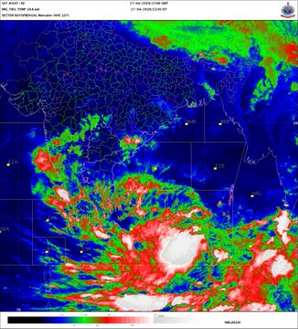
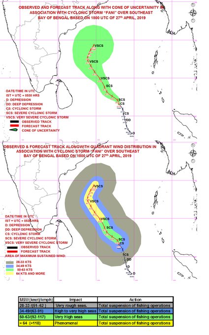
Cyclone Fani is very likely to reach near the coasts of north Tamil Nadu and south Andhra Pradesh by the evening of April 30.
A deep depression over southeast Bay of Bengal developed into cyclonic storm ‘Fani’ on Saturday, and is expected to further intensify into a “severe cyclonic storm”, as per India Meteorological Department’s latest update at 3.02 a.m. on Sunday.
According to the Cyclone Warning Division of the India Meteorological Department (IMD), Cyclone Fani is very likely to reach near the coasts of north Tamil Nadu and south Andhra Pradesh by the evening of April 30.
Cyclone Fani currently lays over east Equatorial Indian Ocean (EIO) and adjoining southeast Bay of Bengal.
“According to our assessment, as of today, it will reach near the coasts of Andhra Pradesh and Tamil Nadu but it is unlikely that will make a landfall. It may recurve before reaching the coast. We are monitoring its path,” Mritunjay Mohapatra, Additional Director General of the IMD, said in Delhi.
Mohapatra also heads the Cyclone Warning Division.


CS ‘FANI’ over SE BoB lay centred at 2330 hrs IST of 27th April, 2019 about 1110 km SE of Chennai . It is very likely to intensify into a Severe Cyclonic Storm during next 12 hours. It is very likely to move northwestwards till 30th & thereafter recurve northeastwards gradually.
40 people are talking about thisTwitter Ads info and privacy
S. Balachandran, Director, Area Cyclone Warning Centre in Chennai, said ‘Fani’ was likely to intensify into a severe cyclonic storm in the next 24 hours.
The storm has been named ‘Fani,’ as suggested by Bangladesh, he said.
Heavy falls at isolated places are very likely over Kerala on April 29 and 30.
Light to moderate rainfall is expected at a few places over north coastal Tamil Nadu and south coastal Andhra Pradesh on April 30 and May 1.
The sea along the coasts of Sri Lanka, Tamil Nadu and Andhra Pradesh is likely to be “very rough” from April 28, the IMD said.
It has advised fishermen along the coasts of Sri Lanka, Tamil Nadu, Andhra Pradesh and Puducherry not to venture into the seas.
The Southern peninsula division comprising all five States of the South India and the Union Territory of Puducherry, Goa and coastal Maharashtra recorded a deficiency of 31%, the IMD said. File | Photo Credit: Reuters
East and northeast India division recorded 23% deficiency.
Pre-monsoon rainfall from March to April, a phenomenon critical to agriculture in some parts of the country, has recorded 27% deficiency, according to the India Meteorological Department (IMD).
The IMD recorded 43.3 millimetres of rainfall across the country from March 1 to April 24 as against the normal precipitation of 59.6 millimetres. This was 27% less of the Long Period Average (LPA).
The highest deficiency of 38% was recorded in the northwest India division of the IMD, which comprises States of Uttar Pradesh, Delhi, Punjab, Haryana, Jammu and Kashmir, Uttarakhand, Himachal Pradesh.
This was followed by the Southern peninsula division comprising all five States of the South India and the Union Territory of Puducherry, Goa and coastal Maharashtra, where the deficiency recorded was 31%, the IMD said.
East and northeast India division recorded 23% deficiency.
The Central India division is the only one to have recorded more 5% rainfall than the normal.
Pre-monsoon showers, thunderstorms and lightning have killed more than 50 people in Madhya Pradesh, Maharashtra, Gujarat and Rajasthan this month.
Several parts of India receive pre-monsoon rainfall which is critical for those regions. The phenomenon, which is usually from March to May end, is vital as it helps in bringing the temperatures down.
The situation also appears to be grim as large parts of the country have been witnessing heating and there has not been any major relief since April 17, said Mahesh Palawat, vice-president (Meteorology and Climate Change), Skymet.
One of the reasons for a pre-monsoon rainfall is excessive heating from March to June which several parts of the country witness. The moisture from the Arabian Sea and the Bay of Bengal aids in creation of thunderstorms, Mritunjay Mohapatra, Additional Director General of the IMD said.
“Pre-monsoon rainfall is important for horticulture crops in some parts of the country. In States like Odisha, ploughing is done in the pre-monsoon season,” he said.
Laxman Singh Rathore, former Director General of the IMD, said in parts of northeast India and the Western Ghats, pre-monsoon rainfall is critical for plantation of crops.
There will be “moisture stress” in case of a deficit, he said.
Crops like sugarcane and cotton, planted in central India, survive on irrigation, but also require supplement of pre-monsoon rains, Mr. Rathore added.
“In the forested regions of Himalayas, pre-monsoon rainfall is necessary for plantations like apple. Due to moisture, pre-monsoon rainfall also helps in minimising the occurrence of forest fires,” he said.
___________________________
Hottest weather yet this season to challenge records in southeastern US early this week
Volume 0% How to keep your child safe on a playground during a heat wave
The southeastern United States will get an early taste of summer as heat and humidity build throughout the region early this week.
While the calendar is nearing May, it will feel like it has jumped to June from portions of the Deep South to the Tennessee River Valley and lower mid-Atlantic.
Some residents may be turning on the air conditioning sooner than they would like and precautions will need to be taken by anyone laboring outside during the hottest time of the day (afternoon hours).
A building area of high pressure out of the Gulf of Mexico will pump in warmth and humidity as April comes to a close, according to AccuWeather Lead Long-Range Meteorologist Paul Pastelok.
High temperatures will surge well into the middle to upper 80s F and may touch the 90-degree-Fahrenheit mark in some areas. Such levels are 10-15 degrees above normal for this time of year.

Temperatures will hit their highest mark yet this year in some areas.
An uptick in humidity and sunshine will bump AccuWeather RealFeel® Temperatures several degrees higher, making it vital for anyone outside to drink plenty of water to stay hydrated.
Light-colored, loose-fitting clothing, sunglasses, hats and sunscreen will also be necessities as the temperature climbs. Doing any type of outdoor exercising or work during the early morning and evening hours can lessen the risk of heat-related illnesses.
Never leave a child or pet in a locked vehicle even with the windows cracked as the temperature can climb to lethal levels in minutes, even during the springtime.
Avoid playgrounds directly in the sun during the afternoon hours when the equipment can be hot enough to cause serious burns.
RELATED:
4 ways medications make you more vulnerable to heat and sun
5 tips runners should know before battling summer heat
Lesser known danger: Hot cars can kill during springtime
How to listen to AccuWeather’s Weather Insider podcast: Get the latest on the ‘why’ behind the current weather
The heat will first crank up across Alabama, Georgia, Tennessee and South Carolina on Monday before it expands into North Carolina and Virginia on Tuesday and Wednesday.
Montgomery, Alabama, and Augusta, Georgia, will near their 2017 daily record highs of 90 and 91 respectively on Monday.
Nashville and Chattanooga, Tennessee; Atlanta and Athens, Georgia; Asheville, North Carolina; and Roanoke and Charlottesville, Virginia, will follow suit on Tuesday with each city challenging its respective record high for the date.

The summerlike conditions will provide great baseball weather for the Atlanta Braves four-game series with the San Diego Padres beginning on Monday evening and may help boost fly balls out of SunTrust Park for home runs.
The heat is likely to persist into Wednesday and perhaps even Thursday along the southern Atlantic Seaboard.
“With a shift of the overall storm track to the north, the South will dry out for the remainder of the month,” Pastelok said.
Mainly dry weather could continue into the first couple days of May.
Storminess will instead focus across the central and southern Plains, where there will be an enhanced risk of flooding as a system brings repeated downpours.
The broad area of high pressure should slow the progression of rain from this system toward the Southeastern states, according to Pastelok.
The stretch of dry weather will be good news for communities that continue to clean up after a slew of severe weather events in recent weeks.


