People in Siang in Arunachal Pradesh and several districts in Assam heaved a sigh of relief as water level in Siang has significantly reduced on Sunday.
Arunachal Pradesh water resources department secretary, Bidol Tayeng said that with the danger of flash flood over, the situation has come to
normal now in all the vulnerable districts.
Assam water resource minister, Keshav Mahanta said, “The government has posted an officer in Pasighat to update the government of
situation. In Assam the water level are receding.”
Ferry services were resumed between Dibrugarh and Dhemaji on Sunday. This service was suspended after flood alert. The water level
in Dibrugarh increased by 1.16 metres from 103.32 metres to 104.48 metres in the last 24 hours upto 7am on Sunday which is below the
danger level of 105.70 metres.
After 7 am the water level has started decreasing by 4 to 6 cm every hour.
People in Siang in Arunachal Pradesh and several districts in Assam heaved a sigh of relief as water level in Siang has significantly reduced on Sunday.
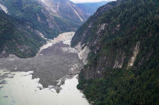
Following landslide in China’s Yarlung Tsangpo and threat of water bomb, six districts in upper Assam had been put on high alert. Lakhimpur, Dhemaji, Dibrugarh, Tinsukia, Sivasagar and Golaghat have been put on a high alert by the state government. Assam and Arunachal Pradesh has gone on alert after the formation of an artificial lake on the Yarlung Tsangpo River after a cliff fell at Milin section of the river, 70 km from Nuxia Hydrological Station in Tibe. East Arunachal Pradesh MP, Ninong Ering said that, “It seems the danger is over. The water level of Siang started receding from Saturday, and went down further on Sunday. So, the imminent threat is no more now. Much water has already flowed down by now.
Hence Siang is calm now.”
In Siang water receded to about 145 meter on Sunday from some 152.97 meter on Saturday at Pasighat. Tsangpo is known as siang in Arunachal Pradesh and Brahmaputra in Assam. On Thursday, Chinese government
informed India that a landslide on the river in Tibet region might burst any time.
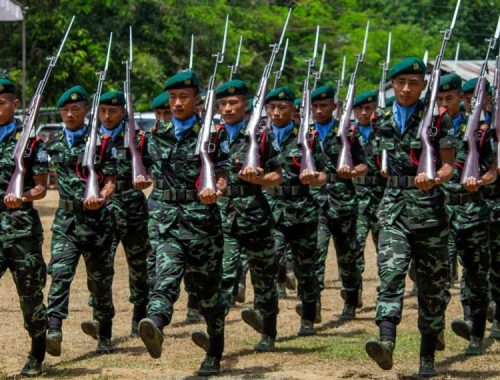
In Arunachal Pradesh eight companies of NDRF were airlifted from Bhubaneswar and deployed at various vulnerable areas. Arunachal
Pradesh water resources department secretary, Bidol Tayeng said that with the danger of flash flood over, the situation has come to
normal now in all the vulnerable districts
Assam water resource minister, Keshav Mahanta said, “The government has posted an officer in Pasighat to update the government of
situation. In Assam the water level are receding.”
Ferry services were resumed between Dibrugarh and Dhemaji on Sunday. This service was suspended after flood alert. The water level
in Dibrugarh increased by 1.16 metres from 103.32 metres to 104.48 metres in the last 24 hours upto 7am on Sunday which is below the
danger level of 105.70 metres.
After 7 am the water level has started decreasing by 4 to 6 cm every hour
By Bikash Singh,
Chinese media reports:
More than 6,000 people were evacuated and more will follow after a barrier lake was formed following a landslide that blocked the Yarlung Tsangpo River in the Tibet autonomous region on Wednesday morning. Its water level continues to rise, local authorities said on Thursday.
The landslide struck around 5 am on Wednesday near Gyalha village in Manling county, plugging the river that originates in Tibet and flows to India, according to the regional emergency response department.
By 7 am on Thursday, the water level of the lake had risen to 59 meters, and the amount of water reached 360 million cubic meters. The water level had been rising at an average speed of about one meter an hour from midnight to 7 am, the department said around noon.
More than 20,000 people in Manling and Medog counties were affected by the barrier lake and more people will be evacuated due to the risk of the barrier lake bursting.
The regional government has activated the highest level of emergency response for geological disasters and evacuated 6,000 residents.
The Ministry of Water Resources also required the regional government to provide hourly information of the water level of the Yarlung Tsangpo River at observation stations upstream and downstream of the barrier lake to Indian authorities.
A 12-member local work team consisting of hydrological and geological experts had arrived at the site by Wednesday. A six-member team sent by the Ministry of Natural Resources arrived at Menling county around 8 am on Thursday, the regional emergency response department said.
Wu Yingjie, Party chief of Tibet, urged the authorities to closely monitor the barrier lake and issue warnings on possible disasters. He also required them to evacuate residents who are threatened by the disaster.
It was the region’s second major geological disaster less in a week. On Oct 11, the Jinsha River, in the upper reaches of the Yangtze River, was blocked by a landslide, creating a barrier lake in Chamdo.
Water from upstream has burst through the blockade in the Jinsha River, causing the water level in the barrier lake to drop significantly, signaling an easing of risks for the lower reaches of the river. But the Ministry of Emergency Management warned on Saturday that the possibility of another landslide near the first landslide site has grown.