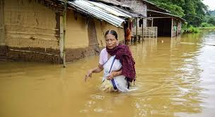
Flood in Assam could be minimised with the help and application of early warning system, says Chandan Kumar Duarah, a science journalist and conservation activist in Assam. Satellite data has been playing a crucial role which was ignored during Assam flood. Several countries including China, Russia and France collaborated with India on sharing satellite images of the scale of inundation. As signatories to the The International Charter Space and Major Disasters, any of the 32 member countries can send a ‘request’ to activate the Charter. This would immediately trigger a request by the coordinators to space agencies of other countries whose satellites have the best eyes on the site of the disaster.
Based on an activation request by the Indian Space Research Organisation (ISRO) on July 17, France’s National Centre for Space Studies, China National Space Administration and ROSCOSMOS of Russia shared satellite images of the flood situation in the districts of Dhubri, Marigaon, Barpeta, Dhemaji, Lakhimpur in Assam with ISRO’s National Remote Sensing Centre. ISRO’s CARTOSAT satellites too got the Indian space agency its own images.
‘Standard practice’
Ravish Kumar, spokesperson of the Ministry of External Affairs, said in response to a query from The Hindu that combining earth observation assets from different space agencies allows resources and expertise to be coordinated for rapid response. This was a “standard practice” and in the past ISRO too had provided information to other space agencies in response to similar requests. In August 2014, for instance, ISRO’s CARTOSAT shared images after an activation request from China after an earthquake struck Yunan province and killed 398.
Since 2000, when the Charter came into operation there have been about 600 activations and data from 61 satellites have helped with disaster operations in 125 countries.