Nepal has issued a new national map incorporating areas also claimed by neighboring India, prompting fierce criticism from New Delhi.
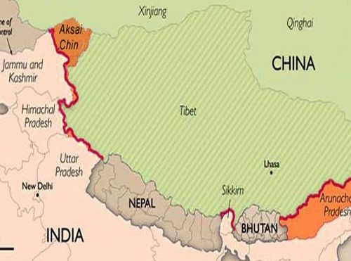
At issue is about 300 square kilometers (115 square miles) of mountainous land incorporating Lipulekh, Limpiyadhura and Kalapani. Nepal’s new map locates the small stretch of disputed land within its northwest border, between China and India.
The cartographic dispute is based on differing interpretations of treaty signed by the British East India Company with the King of Nepal in 1816, which established the boundary between the two countries. Though both sides have long claimed the territory as their own, Wednesday marked the first time Nepal issued a map including the disputed area. India already includes the contested area in its own official map.
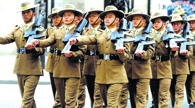
The dispute was reignited on May 8, when Indian Defense Minister Rajnath Singh virtually inaugurated a newly built 80-kilometer (50-mile) road connecting India’s Dharchula to Tibetan autonomous region via the Lipulekh pass, which is part of the contested area.
India expects the route to facilitate trade and the movement of Hindu pilgrims to Mansoravar lake in Chinese-administered Tibet, which is considered auspicious.
But hundreds of angry Nepali protesters took to the streets across Nepal opposing the Indian inauguration, burning Indian Prime Minister Narendra Modi’s effigy and called it a violation of their territorial sovereignty.
Nepal responded quickly. On May 9, its foreign ministry issued a statement asking India to “refrain from carrying out any activity inside the territory of Nepal.”
India responded, saying that the inaugurated road section lies “completely” within its territory, and that the two countries would discuss it after the worst of the coronavirus pandemic had passed. “Both sides are also in the process of scheduling Foreign Secretary level talks which will be held once the dates are finalized between the two sides after the two societies and governments have successfully dealt with the challenge of Covid-19 emergency,” the Indian foreign ministry said in a statement.
The next day, the Nepali government summoned the Indian ambassador over the matter.
Speaking in parliament on Tuesday, Nepal’s Prime Minister KP Sharma Oli suggested India was bullying Nepal, and warned, “We won’t let go the issue of Lipulekh, Limpiyadhura and Kalapani. This is our land and we will reclaim it. It is not a disputed land. It is our land. India created unnecessary controversy by claiming it as theirs. This government will make concrete efforts to reclaim the territories.”
Even China weighed in that day, with Chinese foreign ministry spokesperson Zhao Lijian saying during a daily press conference: “We hope the two countries will resolve their differences properly through friendly consultations and refrain from taking any unilateral action that may complicate the situation.”
On Wednesday, Nepal officially unveiled its revised and expanded national map — a move that India’s foreign ministry quickly criticized as “unilateral” and lacking in “historical facts and evidence.” “Such artificial enlargement of territorial claims will not be accepted by India,” the ministry added in its statement.
Nepal has not explained why the areas were not previously included in its national map.
Unveiling Nepal’s new political map that includes territories on Wednesday, central minister Padma Kumar Aryal expressed hope India will take it “in a positive way”. This is an unusual optimism to settle a boundary question.
Aryal did not elaborate her “positive” remark. Given the nature of India-Nepal relation, however, indicates that the Nepal government hopes India will factor in what is going on domestically in Nepal’s politics
THE BACKSTORY: OLI’S PM CHAIR
Nepal is being ruled by a relatively upstart political party, the Nepal Communist Party (NCP), which turned two over last weekend. The two-year-old party came into being with China’s ruling communist party after merger of two dominant communist parties of Nepal – the Marxist-Leninist and the Maoist.
Nepal’s Prime Minister KP Sharma Oli shares the chair of the Nepal Communist Party with Pushpa Kumar Dahal, more commonly known as Prachanda. Oli is from the Marxist-Leninist stream and Prachanda from Maoist faction.
Oli became the prime minister following an electoral victory in 2017 and a compromise between the two factions in the ruling party in 2018. But his position in the Nepal’s PMO has not been secure. There has been pressure on him to make way for a Maoist prime minister.
Covid-19 outbreak in Nepal and the failure of the Oli government to manage the disease in the country only mounted pressure on the prime minister, who was not ready to let go the reins of the power out of his hand.
Though, he once proposed to resign in favour of Bamdev Gautam. But the other factions, particularly the one under Prachanda and Madhav Kumar Nepal did not agree.
Then in the middle of Covid-19 outbreak, the Oli government promulgated two ordinances on April 20. They were not related to Covid-19 strategy. These laws amended the Political Parties Act of Nepal making it easier to split a party.
This move baffled political observers as the Nepal Communist Party has majority in the country’s parliament. This, however, exposed the fault-lines lying beneath the surface unity of the party, and also the growing pressure on Oli to quit.
The Kathmandu Post reported that the approval for the ordinances from President Bidya Devi Bhandari came while a secretariat meeting was underway to discuss the ordinances. The daily called it “well-choreographed move”.
Soon after the ordinances were brought out, the rival faction stepped up ante against Oli. Prachanda took charge of the rival faction forcing Oli to withdraw the ordinances in four days.
This was also the time when Chinese ambassador in Nepal got involved holding meetings with both factions and also with President Bhandari. A compromise was reached. But public opinion was going against the government and the ruling party.
Some time in between a strategy was devised to deflect public attention from crisis in the government and its failure to tackle Covid-19 crisis. National pride became the rallying point. Oli has a history of thriving on anti-India sentiments.
India soon opened new Kailash Mansarovar route through Lipulekh pass. Nepal protested. The November 2019 updated map released by India provided the launching pad.
India had released its new political map following creation of two Union Territories of Jammu and Kashmir, and Ladakh from erstwhile state of Jammu and Kashmir. The map can be seen here.
Nepal had then protested over inclusion of Kalapani in India’s map. India had then said its boundaries with Nepal had not been altered in the new map.
Six months later, Nepal has now released its new political map. Its old map obviously did not show Kalapani, Lipiyadhura and Lipulekh as its territories. These areas have not been under Nepal’s administration.
There is more to Kalapani story and Oli’s anti-India stance. During his first term as Nepal’s prime minister, there was a constitutional crisis in Nepal fueling anti-India sentiments with India unofficially imposing blockade for months. To counter India, Oli had signed a series of agreements with China.
His remark that novel coronavirus from India is more lethal than the variants from Italy and China, is convenient politicking to raise an anti-India sentiment among his political constituencies.
The issue
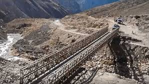
The main issue is that Lipulekh Pass is considered a disputed border region by Nepal and both the countries claim it to be a part of their territory. India has always been clear on this and considers Lipulekh within the country borders. On Friday (May 8), the Defence Minister Rajnath Singh had inaugurated the new route to reach Kailash Mansarovar. Indians and Tibetans have been in border trade for quite some time now at the Lipulekh Pass and this new road links the pass to Dharchula, which is a town in Pithoragarh, Uttarakhand in India. Soon after the inauguration, Nepal raised an objection to the new route.
As of now, the second stretch is being converted into a double lane road by the Border Roads Organisation. Till now, 76 km of the 80 km stretch, (that will cut down the travel time to two days by vehicles) is completed and the last 4 km stretch till Lipulekh Pass is expected to be completed by the end of 2020.
A statement released by the Ministry of Defence said, “The road originates from Ghatiabagarh and terminates at Lipulekh Pass, the gateway to Kailash-Mansarovar. In this 80-km road, the altitude rises from 6000 to 17060 ft. With the completion of this project, the arduous trek through treacherous, high-altitude terrain can now be avoided by the pilgrims of Kailash-Mansarovar”.
Why is Nepal objecting to the connecting road for Kailash Mansarovar through Lipulekh Pass?Credit: iStock
The new route via Uttarakhand will have three main stretches.
1) The first one is a 107.6 km long road from Pithoragarh to Tawaghat.
2) The second will be from Tawaghat to Ghatiabgarh on a 19.5 km single lane.
3) The third is the 80 km from Ghatiabgarh to Lipulekh Pass at the China border.
The Lipulekh stretch can be only covered on foot and almost takes five days to reach. Not only this, a number of accidents have happened on this road. Till now, Indian pilgrims could reach Kailash Mansarovar via three routes only, through Sikkim, Uttarakhand and Kathmandu (the capital city of Nepal).